Subsurface Drafting Services

Redefine Geo-Graphic Design

Our Valued Customers

Get In Touch

We’d love to bring your subsurface work to life! Send Your inquiries here.

Bespoke

Geoscience Drafting – Services

Based in Denver Colorado (USA), Define Geo-Graphics specialises in providing subsurface drafting and graphics services with a deep focus on Geoscience to the energy sector.

We are run by Geoscientists for Geoscientists!
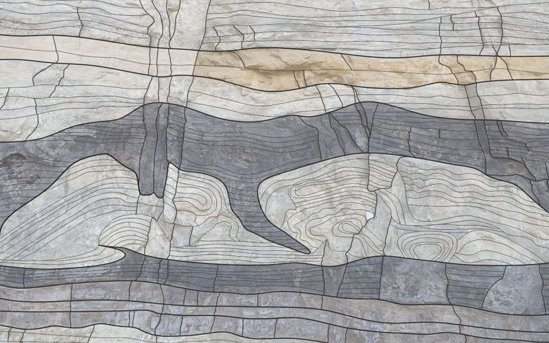
Compare the
Input vs Output

Move the slider from left to right to compare the input vs output from our cross section drafting services. The right example is a professionally drafted cross section and the left is a “screen-shot” from an interpretation package that you’ll typically see in presentations from subsurface teams.

Define Geo-Graphics

Subsurface drafting Services

We specialise in producing high quality graphics that will elevate your geo-communication and get YOU noticed.

Farm-Out Material Preparation & Marketing

Level up your subsurface marketing with our:

  • Farm-out flyers
  • Marketing material
  • Investor relations

Mapping & GIS Solutions

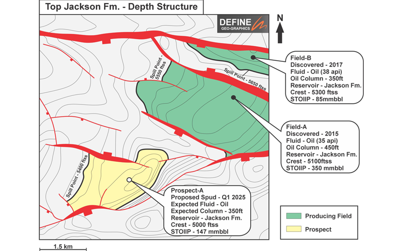
  • Basemap drafting (Prospect / structural / data / portfolio maps, etc)
  • Georeferencing
  • Shapefile manipulation and digitisation
  • GIS and mapping displays

General Support & Technical QC

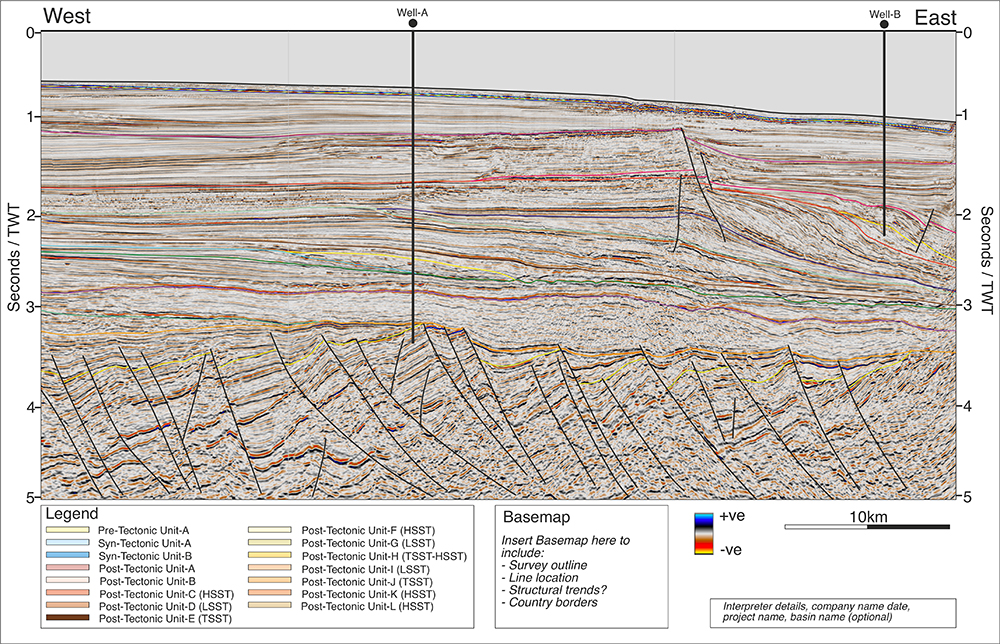
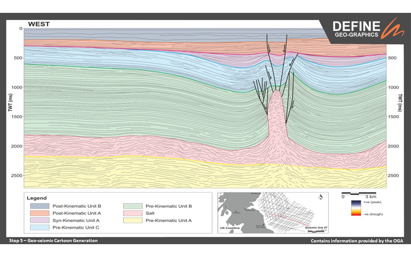
  • Geo-seismic cross section drafting
  • Well correlation panel and prognosis diagrams
  • ⁠Redrafting of published figures
  • ⁠Technical peer review / Geologic sense check
  • ⁠Geoscience and English language QC
  • Presentation editing

Specialist Geoscience Services

  • Seismic and Structural Interpretation
  • Chrono/Sequence Stratigraphy
  • 3D Geological Models
  • 3D Textured Animations

Our Process

How it Works

Mapping out our step by step process to understand how we transform your interpreted seismic sections from your workstations into publishable material ready for investor reports, farm-out flyers, publication, management presentations or simply for office decoration!

Project Delivery = 10 Days Total

Step 1

Provide us with a high resolution image of your seismic data (with and without interpretation). We can advise on the best practices this on all major software packages (Petrel/Kingdom/DUG). We will then load this image our graphic design software.

Step 2

We then digitise your horizons and faults interpretation.

Step 3

After digitisation of all geological features, we fill in the stratal units to visualise the subsurface image.

Step 4

Digitisation of the internal stratal patterns within the sedimentary packages. This will greatly enhance your understanding of the facies and seismic stratigraphy.

Step 5

A cartoon geological section is produced with the underlying seismic removed. These sections are very popular for investor and internal company reports as they are more easily digestible for non-geoscientists.

Become A
Geo-Drafting Expert

Our detailed 9 module course covers everything you need to know to become a Geological Drafting pro. 

 With this hands-on course we will provide you with the tools you require to elevate your geo-communication using the CorelDRAW software.

The graphic design course is exceptionally well-structured and packed with useful, practical insights. Highly informative and engaging —definitely recommend it to anyone looking to enhance their graphics skills.
Lorenzo Di Lauro PHd | Geologist
The graphic design course is exceptionally well-structured and packed with useful, practical insights. Highly informative and engaging—definitely recommend it to anyone looking to enhance their graphics skills.
Lorenzo Di Lauro PHd | Geologist
Define Geo's Introduction to Geological Drafting Training Course is an absolute must attend for any young geo's or graduates coming into the oil and gas or mining industries. It will give them the tools to be able to communicate complex subsurface issues to a broad audience, a key skill in todays world.
Senior Geoscientist
The Geological Drafting course offered by Define Geographics is clear, well-structured, and highly effective. It is an excellent resource for improving communication across multiple levels and for supporting brainstorming and the development of new exploration concepts. I thoroughly enjoyed the experience and strongly recommend it to anyone involved in multidisciplinary exploration workflows.
Giacomo Firpo | Senior Geoscientist | Eni
The Geological Drafting course by Define Geographics was a valuable experience. As a Geoscientist, I found the structured modules and focus on practical application with CorelDRAW especially useful. It enhanced my skills in geological drafting and 3D visualization. I now feel more confident using these tools professionally and highly recommend the course.
Heba Hamdy | Exploration Geoscientist | SNOC
I would fully recommend this course - it provides an excellent set of tools that I will use for years to come!
Geologist
I would fully recommend this course - it provides an excellent set of tools that I will use for years to come!
Geologist
This training course was excellent - it provides a series of actionable steps and processes that I use weekly in my job.
Junior Geologist
This training course was excellent - it provides a series of actionable steps and processes that I use weekly in my job.
Junior Geologist

How Can We Help?

Frequently Asked Questions

Articles

Wall of Information

Geoseismic Interpretation: Why Clear Graphics Still Drive Better Subsurface Decisions

A seismic section on its own tells a story.A geoseismic interpretation ensures that story is clearly understood. In subsurface teams, the gap between technical insight...

Lost in Translation? How Fractures Confuse Your Audience

How Fractures Confuse Your Audience (But Clear Graphics Can Help!) ️➡️ Hey there, geology enthusiasts! Today, we're tackling a common challenge faced by subsurface...

Time is Money: Streamlining Subsurface Drafting for Efficient Project Delivery

In the fast-paced world of subsurface exploration and development, clear communication is paramount. Geoscientists rely on effective drafting to convey complex data and...

Stuck Explaining Reservoirs? Visuals Unlock Communication!

Struggling to explain how rock formations impact fluid flow in reservoirs? Jargon and complex structures can create a communication gap. Graphics bridge the gap! In...

Geo-seismic Interpretation – a geoscientists communication hack!

Geos all over the world, for many years have displayed subsurface data to other geos as well as to non-technical stakeholders. As I’m sure many of you will know, this...

There is No Feeling Quite Like it – New Seismic Dataset!

There is No Feeling Quite Like it (For a Geoscientist) - Loading a Brand-NEW Seismic Dataset! Every geoscientist out there will get us here! Nothing quite excites an...

Tired of Unclear Maps in Your Farm-Out Flyers and Presentations?

You're not alone. We see it all the time: poorly labeled maps burying key information in a sea of clutter. But impactful visuals are essential for grabbing...

Outcrop : Nature’s Reservoir Blueprint for Investors

Geoscientists, listen up! Outcrops, like this beauty from Utah , are a treasure trove of reservoir architecture secrets. But how do we translate that knowledge for...

Vivid Graphics are the Key to Unlocking Value in Geoscience!

First impressions matter, especially when it comes to securing investment. In geoscience, complex data like seismic lines (as seen below) needs a clear translation to...

From Stromatolites to Success: Visualizing Reservoir Textures for Everyone

Explaining complex reservoir textures to non-experts can be a headache! But what if, with the helping hand of surface geology you could create powerful visuals?...

Testimonials

Happy Customers

Define Geographics provided CNOOC with a quick turnaround of subsurface drafting products. Their prompt response delivered a quality product to support our ongoing operations.
CNOOC International
Define Geographics provided CNOOC with a quick turnaround of subsurface drafting products. Their prompt response delivered a quality product to support our ongoing operations.
CNOOC International
Define Geographics took a challenging request and delivered quickly and professionally - I look forward to using them again.
Kristopher Purens
UROBOROS INNOVATIONS
Define Geographics took a challenging request and delivered quickly and professionally - I look forward to using them again.
Kristopher Purens
UROBOROS INNOVATIONS
We used define geo-graphics for drafting seismic lines for presentations. We found the team very cooperative and professional. The work was done quickly and currently. I fully recommend their service If you need to save time on drafting and require high quality work.
Dr. Yuval Bartov
MOSESTRO EXPLORATION LLP

Get In Touch

Contact Us

We can tailor any of our drafting projects to suit your requirements.  Simply send us an email or use the contact form to submit any queries and we will be in touch within 48 hours to provide you with a free quote!

EMAIL US